3D Suvey Drone Srl
Social
Phone

Via XXV Aprile 171,
20092, Cinisello Balsamo (Milano)
P. IVA 12722350969
3D Survey Drone
Privacy policy - Cookie policy
© 3D Survey Drone | All Rights Reserved
TOPOGRAPHY AND 3D SURVEYS WITH DRONES AND LASER SCANNERS


WHAT WE DO
We position ourselves as a support and partnership tool for companies, public administrations, and professionals operating in the field of territorial and architectural planning and design. We utilize innovative survey tools that enable the acceleration and improvement of traditional workflows. Specifically, we focus on 3D survey activities aimed primarily at acquiring and creating Point Clouds, 3D models, and high-definition Digital Twins. These tools provide professionals with a comprehensive range of data and information that offers the best possible representation of the surveyed reality. We specialize particularly in Aerophotogrammetric Surveys using Drones and Laser Scanner Surveys, as well as in the related processing and delivery of cartographic, planimetric, and architectural data in GIS and CAD environments. We offer a complete, high-technology service tailored to the specific needs of the client.


<< Our OUTPUT is the best INPUT that the designer can use to bring their work to life>>

MISSION
3D Survey Drone srl provides tools and solutions in a market where it is increasingly necessary to adapt and invest in technological solutions that enhance processes and promote more efficient working models. The cultural background of our company, shaped by the work experiences of the founding partners and the network of professionals we rely on, guides us to be attentive and sensitive to issues of sustainable development, the protection of cultural and landscape heritage, and social inclusion. The goal our company aims to pursue and guarantee over time is the increasing satisfaction of our clients and the creation of a solid network of relationships and partnerships with all the various public and private entities involved in territorial development, planning, and design.

SERVICES
AERIAL SURVEYS AND TERRITORIAL MAPPING
Photogrammetry, both terrestrial and via DRONE, enables the digitization of structures with greater efficiency and precision compared to traditional topographic methods, allowing for surveys in otherwise inaccessible areas. Using advanced technologies and the integration of topographic data, we offer a complete range of outputs: digital as-built scans, point clouds in standard formats, as well as CAD, BIM, 3D, Mesh, orthomosaics, DEM, DTM, and detailed contour maps. Ideal for topographic analysis, monitoring construction sites and infrastructure, environmental studies, urban planning, and natural resource management.


GROUND-BASED LASER SCANNER SURVEYS
Using 3D LASER SCANNER surveys, we convert physical structures into digital data, providing highly detailed and precise documentation of the current state. Through the use of cutting-edge equipment and the integration of topographic data, we offer digital as-built scans, point clouds in standard formats, including Autodesk, and a wide range of outputs such as CAD, BIM, 3D models, and point clouds. Ideal for the precise three-dimensional surveying and data collection of objects, buildings, structures, and infrastructures. Essential for architectural design, civil engineering, infrastructure, as well as architectural restoration and the documentation of cultural heritage assets.


INTEGRATED 3D SURVEYS
This advanced methodology combines the versatility and extensive coverage of aerial surveys conducted with drones, capable of capturing high-resolution data over large areas, with the millimeter precision of ground-based laser scanner surveys, ideal for architectural details and complex structures. This integrated approach ensures comprehensive documentation, from a broad overview to the finest details, facilitating a variety of applications such as detailed design, accurate conservation of cultural heritage, and detailed environmental analysis.


DATA PROCESSING
After data collection, advanced processing transforms the data into 3D models, point clouds, and other visualizations. This process supports various fields such as architecture, engineering, and conservation, providing tools for decision-making and presentations. It includes the creation of CAD, BIM, meshes, orthomosaics, and detailed maps, essential for design and analysis.


<< True progress occurs only when the benefits of new technology become available to everyone >> (Henry Ford)

FIELDS OF APPLICATION


TOPOGRAPHY AND TERRITORY
Mapping and surveying, even of very large or inaccessible areas.

ARCHITECTURE AND ENGINEERING
Surveying of civil and industrial buildings, both interior and exterior, and related infrastructures.

RESTORATION AND CULTURAL HERITAGE
Surveying of historical buildings, artworks, archaeological sites and artifacts, and degradation analysis.

GEOLOGY AND QUARRIES
Environmental surveying in critical situations such as hydrogeological instability, floods, landslides, and surveying of extraction sites for volume calculation of moved materials.

INSPECTIONS AND MONITORING
Surveys and video inspections on construction sites for structural checks, as-built conditions, progress status, degradation analysis, and damage detection.

ENAC Certification
We are listed in the register of ENAC certified operators, authorized to operate drones in categories A1/A3 and A2, including IT-STS Scenarios. This recognition attests to our ability to ensure safe aerial operations in compliance with the highest standards.
Confined Spaces Certification
Our specific training ensures the necessary certification to safely operate in confined spaces and manage the complexities associated with accessing and working in restricted and potentially hazardous environments, in compliance with current regulations.

<< Creating a 3D model allows for the extraction of a series of derived and complementary data at a later time without needing to return to the field. >>

Explore the sample 3D models and discover the advantages of having a digital twin on your PC.


3D SURVEY DRONE SRL - INTRODUCTION
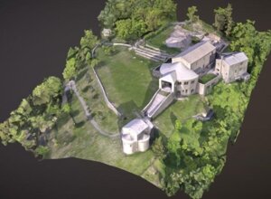
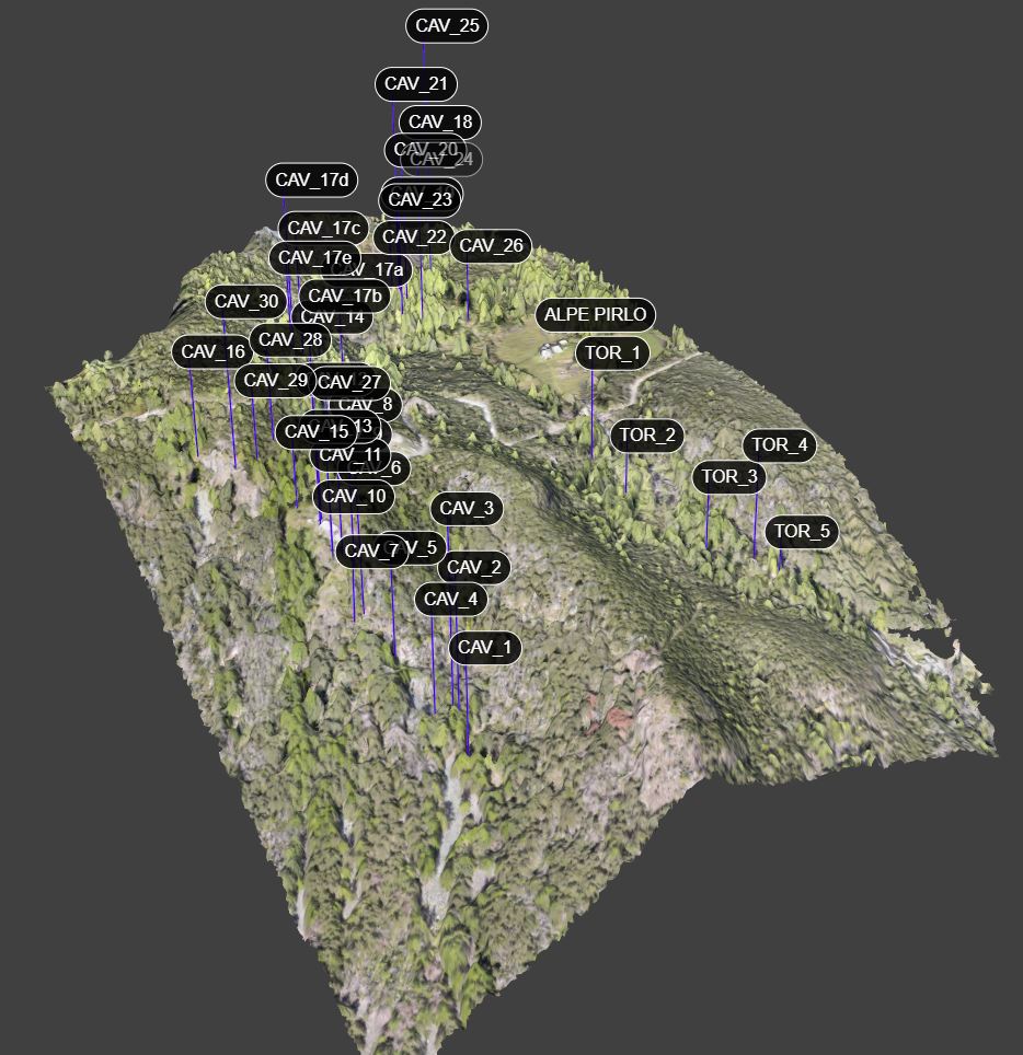
AEROPHOTOGRAMMETRIC SURVEY IN MOUNTAINOUS ENVIRONMENTS AND DATA PROCESSING ON GIS PLATFORM
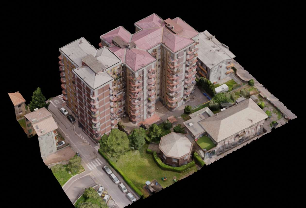
FACADE SURVEY WITH DRONE AND CAD PROCESSING
Where We Are
For more information and quotes, contact us now.